Nevada King Commences 6,400m Deep Drilling Program at Iron Point Targeting Lower Plate Gold Mineralization
Thursday, January 6, 2022
VANCOUVER, BC, January 6, 2022 – Nevada King Gold Corp. (TSX-V: NKG; OTCQX: NKGFF) (“Nevada King” or the “Company”) is pleased to announce commencement of a 23 hole, 6,400m drill program at the Company’s 100% owned Iron Point Gold Project (“Iron Point” or the “Project”) in Humboldt County, Nevada. Located at the juncture between the prolific Getchell and Battle Mountain gold trends, Iron Point is one of the last remaining district-scale Carlin-type gold exploration targets in Nevada.
Highlights
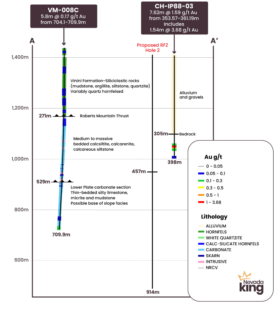
Nevada King has commenced a 6,400m drill program at Iron Point to further test Carlin-type gold mineralization hosted in Lower Plate carbonate rocks beneath the Roberts Mountain Thrust. This program is designed to follow up on initial drilling completed in 2019 by the Company in which a thick sequence of Lower Plate carbonate rocks was encountered in core hole VM-008C. This hole bottomed in mineralization intercepting 5.8m grading 0.17 g/t Au associated with strongly elevated pathfinder elements.
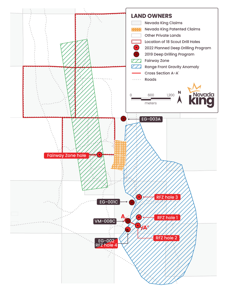
In this program, Nevada King has planned 23 holes (Figure 1) with five of those holes (totaling 4,000m) targeting deep, Lower Plate gold mineralization.
Four of these deep holes are located along the Range Front Zone and are currently being pre-collared using a mud-rotary drill rig to depths of approximately 455m with casing installed. The fifth deep hole will be pre-collared in the “Fairway” Zone, 2.8km NNW of VM-008C, using an RC drill rig to a depth of approximately 455m (see Figure 2).
Additionally a scout reconnaissance program of 18 shallow RC drill holes totaling 2,400m began in November 2021 and is designed to probe unexplored areas near the north end of the Iron Point claim block where geophysical surveys and interpretation by the Company indicate the potential for shallow, uplifted blocks of Lower Plate stratigraphy. Sample results from several of these initial scout holes have been submitted for assay with results pending.
Lewis Teal, M.Sc., B.Sc. Geo., Independent Technical Advisor to the Company at Iron Point, stated: “Occurring strategically at the regional intersection of Nevada’s Battle Mountain – Cortez and Getchell gold belts, the Iron Point project represents a significant district-scale opportunity for discovery of a Carlin-type gold deposit, in under-explored terrain, hosted in Lower Plate carbonate rocks beneath the Roberts Mountains Thrust. The setting at Iron Point is enhanced by the wide-spread occurrences of historical near-surface, lower-grade gold drill intercepts which are hosted in the overlying Upper Plate siliciclastic assemblage above the Roberts Mountains Thrust, as documented and modeled by Nevada King’s project exploration team.”
Range Front Zone (“RFZ”) Deep Drill Program
A mud-rotary drill rig is being mobilized to Iron Point to drill three deep pre-collars along the RFZ. Each pre-collar will be drilled to a nominal depth of approximately 455m and casing will be set to allow for follow-on diamond drilling to advance each drill hole to a depth up to approximately 915m. The objective of these drill holes is to step-out from areas of known mineralization, and at the same time, test the hanging wall side of the range front fault. A gravity survey completed in 2020 indicates the presence of a large down-dropped block extending to the east up to 3.5km from the range front fault beneath alluvium. If favorable Lower Plate carbonates are discovered in this down-dropped block, the target area along the RFZ will be greatly expanded.
Proposed RFZ holes 1 and 2, collared 250m apart in a north-south direction, will serve as 350m step-outs to the ENE and ESE of deep drill hole VM-008C drilled in 2019. VM-008C bottomed in 5.8m grading 0.17g/t Au accompanied by elevated As, Sb, and Hg in silicified Lower Plate thin-bedded “dirty” limestone with an appearance similar to the Roberts Mountain Formation. This area is considered to have good potential for higher grade gold mineralization at depth. Proposed RFZ drill hole 2 is located approximately 90m northwest of historic hole CH-IP88-03 drilled by Chevron in 1988 that intersected 7.62m grading 1.59 g/t Au beginning 353.57m downhole, including 1.54m grading 3.68 g/t Au at 355m. CH-IP88-03 drilled through 305m (1,000ft) of alluvium before entering bedrock, however the rock unit hosting gold is unknown at this time, (see Figure 4).
Proposed RFZ drill hole 3, situated 600m to the NNE of drill hole VM-008C, is a 265m step-out of mineralization encountered in 2019 drill hole EG-001C. Grade-thickness contours of nearby historic drill holes indicate an ENE orientation to Au mineralization in the upper plate siliciclastic rocks, a vector that coincides with a pronounced shoulder in the gravity dataset. EG-001C intersected the following zones of low-grade gold mineralization:
25.9m grading 0.198 g/t Au from 22.9-48.8m downhole associated with brecciated quartzite, strong sulfide veining, and intrusive dikes
10.7m grading 0.303 g/t Au and 50.4 g/t Ag, from 172.2-182.9m downhole hosted in quartzite with intrusive dikes, breccia, and quartz-sulfide veining.
18.3m grading 0.309 g/t Au from 358.1-376.4m downhole hosted in granodiorite and endoskarn
EG-002, the fourth planned deep test in the RFZ, is a 265m step-out to the south of VM-008C. This drill hole was pre-collared to 305m during the 2019 program but a core tail was not drilled at that time. A 610m core tail is planned during the 2022 program, bringing the total planned depth of this hole to 915m. This hole is situated within the same structural block as VM-008C and is expected to fully test prospective Lower Plate stratigraphy in this area.Diamond drill core tails will be completed in each of these four pre-collar holes to depths up to 915m.
Fairway Zone Deep Drill Program
During 2021, Nevada King’s geologists compiled extensive datasets including from multiple geophysical surveys conducted in 2020 including gravity, CSAMT, and aeromagnetics, along with historic soil and drill results, resulting in identification of a profound NNW-trending structural corridor, referred to as the “Fairway” Zone. This zone displays alteration and gold mineralization centered along an interpreted intrusive complex and extends a distance of 4.5km, projecting under the post-mineral basalt flows to the north. A single deep drill hole, collared 2.8km NNW of VM-008C, is planned as an initial test of this target area. This test will be started with a cased RC pre-collar drilled to a planned depth of 457m and finished with a diamond drill core tail to a planned total depth of 760m. Prospective Lower Plate stratigraphy is expected to be encountered in this area
Scout Reconnaissance Drill Program
Post-mineral basalt flows cap a plateau covering a 16 sq. km area in the northeast portion of the Iron Point claim block. Historic drilling along the NNW-trending projection of the Fairway Zone near the center of the basalt flows intersected intervals up to 39.6m grading 0.22 g/t Au including 3.05m of 1.85 g/t Au. Because the Company does not possess cuttings or geological logs from these historic holes to determine the host rock and nature of this mineralization, it was decided to undertake a scout reconnaissance drill program to help identify and delineate future deep exploration in this target area. The purpose of this scout program is to determine the thickness of the basalt cover as well as to identify the underlying bedrock geology, alteration, and vectors to mineralization. Results will also be used to ground-truth CSAMT data and refine the subsurface interpretation.
Foremost 1500 and Canterra-312 buggy-mounted reverse-circulation rigs were mobilized to Iron Point in mid-November and early December 2021, respectively, to focus on three areas under basalt cover (See the hachured areas in Figures 2 and 3). Prior to the end of year drilling break, a series of shallow vertical holes totaling 1,790m were completed to an average depth of 150m. An additional 490m of drilling is planned for completion in January using the Canterra-312 rig. Initial results indicate the thickness of basalt drilled ranges from 20-69m, and that bedrock geology consists of Comus and Preble formations. Zones of quartz veining, sulfides and alteration were encountered in various holes in this scout program. Drill samples were submitted for analysis to American Assay Labs in Reno, Nevada in late November and late December 2021 and results are pending.
Project Background
The Iron Point Gold Project is located 35km east of Winnemucca, Nevada, at the intersection of the Battle Mountain and Getchell gold belts, and on trend from several world-class gold mines including Twin Creeks (12 Moz Au), Turquoise Ridge (16 Moz Au), and Marigold (4 Moz Au).
Since the mid-1960s, the Iron Point district and surrounding area have been explored by numerous companies for different commodities, including gold and vanadium, beginning with Newmont in 1966 and continuing to Miranda Gold in 2008. Exploration efforts had mainly focused on shallow gold targets (<300m depths) and the potential for a deeper Carlin-type gold deposit in Lower Plate rocks remains virtually untested.
At Iron Point, Upper Plate Ordovician Vinini Formation overlies interpreted Lower Plate Silurian-Devonian Roberts Mountain Formation, separated by the Roberts Mountain thrust fault dipping shallowly to the west. North-south striking normal faults down drop stratigraphy to the east along a range front fault thus resulting in areas to the east being covered by alluvium. Some of the strongest Carlin-type gold pathfinder element geochemistry anomalism known in Nevada occurs at Iron Point in rocks immediately west of the range front fault occurring over an approximate 5 km strike distance. Anomalous gold mineralization also occurs along this 5 km trend. Historic drilling has encountered multiple intervals of significantly anomalous gold mineralization in Upper Plate and Lower Plate stratigraphy immediately west of the range front fault. This includes an interval of Carlin-type gold mineralization occurring along the range front fault and interpreted to be smeared fault gouge originating from deeper levels.
Recent drilling that penetrates the upper levels of the Lower Plate rocks encountered an interpreted recumbent Zed-fold parallel to and immediately west of the range front fault. This recumbent Zed-fold is also partially exposed in an erosional window near the north end of the target area near drill hole EG-003A. A similar geologic setting including recumbent Zed-folding along a range front fault is host to extensive gold-mineralization at Newmont’s Twin Creeks mine located approximately 25 miles northeast of Iron Point. The primary target for Carlin-type mineralization at Iron Point is within Lower Plate rocks caught up in Zed-folding in proximity to the range front fault.
Figure 1. The Iron Point Gold Project located at the intersection of the prolific Getchell and Battle Mountain gold trends.
Figure 2. Map of Iron Point Gold Project showing location of recent and planned exploration activities.
Figure 3. Detailed map of Iron Point Gold Project showing location of recent and planned exploration activities.
Figure 4. Cross Section A-A’ across RFZ target area from 2019 Nevada King core hole VM-008C to 1988 Chevron RC hole CH-IP88-03, showing location of proposed RFZ hole 2.
Qualified Person
The scientific and technical information in this news release has been reviewed and approved by Calvin R. Herron, P.Geo., who is a Qualified Person as defined by National Instrument 43-101 (“NI 43-101”).
About Nevada King Gold Corp.
Nevada King is the third largest mineral claim holder in the State of Nevada, behind Nevada Gold Mines (Barrick/Newmont) and Kinross Gold. Starting in 2016 the Company staked large project areas hosting significant historical exploration work along the Battle Mountain trend located close to current or former producing gold mines. These project areas were initially targeted based on their potential for hosting multi-million ounce gold deposits and were subsequently staked following a detailed geological evaluation. District-scale projects in Nevada King’s portfolio include (1) the 100% owned Atlanta Mine, located 100km southeast of Ely, (2) the Lewis and Horse Mountain-Mill Creek projects, both located between Nevada Gold Mines’ large Phoenix and Pipeline mines, and (3) the Iron Point project, located 35km east of Winnemucca, Nevada.
The Atlanta Mine is a historical gold-silver producer with an NI 43-101 compliant pit-constrained resource of 460,000 oz Au in the measured and indicated category (11.0M tonnes at 1.3 g/t) plus an inferred resource of 142,000 oz Au (5.3M tonnes at 0.83 g/t). See the NI 43-101 Technical Report on Resources titled “Atlanta Property, Lincoln County, NV” with an effective date of October 6, 2020, and a report date of December 22, 2020, as prepared by Gustavson Associates and filed under the Company’s profile on SEDAR (www.sedar.com).
For more information, contact Collin Kettell at collin@nevadaking.ca or (301) 744-8744.
Neither the TSX Venture Exchange nor its Regulation Services Provider (as that term is defined in the policies of the TSX Venture Exchange) accepts responsibility for the adequacy or accuracy of this release.
Cautionary Statements Regarding Forward Looking Information
This news release contains certain “forward-looking information” and “forward-looking statements” (collectively “forward-looking statements”) within the meaning of applicable securities legislation. All statements, other than statements of historical fact, included herein, without limitation, statements relating the future operations and activities of Nevada King, are forward-looking statements. Forward-looking statements are frequently, but not always, identified by words such as “expects”, “anticipates”, “believes”, “intends”, “estimates”, “potential”, “possible”, and similar expressions, or statements that events, conditions, or results “will”, “may”, “could”, or” should” occur or be achieved. Forward-looking statements in this news release relate to, among other things, the Company’s exploration plans and the Company’s ability to potentially expand mineral resources and the impact thereon. There can be no assurance that such statements will prove to be accurate, and actual results and future events could differ materially from those anticipated in such statements. Forward-looking statements reflect the beliefs, opinions and projections on the date the statements are made and are based upon a number of assumptions and estimates that, while considered reasonable by Nevada King, are inherently subject to significant business, economic, competitive, political and social uncertainties and contingencies. Many factors, both known and unknown, could cause actual results, performance or achievements to be materially different from the results, performance or achievements that are or may be expressed or implied by such forward-looking statements and the parties have made assumptions and estimates based on or related to many of these factors. Such factors include, without limitation, the ability to complete proposed exploration work given the global COVID-19 pandemic, the results of exploration, continued availability of capital, and changes in general economic, market and business conditions. Readers should not place undue reliance on the forward-looking statements and information contained in this news release concerning these items. Nevada King does not assume any obligation to update the forward-looking statements of beliefs, opinions, projections, or other factors, should they change, except as required by applicable securities laws.